
Hiking Route – Paths of Nature and Culture
Description
The Hiking Route – Paths of Nature and Culture serves as a cornerstone of the Banat cross-border active tourism portfolio, bringing together the region’s natural heritage, cultural landscapes, and community traditions into a unified experiential tourism product. This route represents the essence of eco-conscious, interpretive tourism — slow-paced, immersive, and educational. It enables visitors to discover the transformation of Banat’s geography from the flat, steppe-like plains of Serbia to the forested mountain ecosystems of Romania.
GEOGRAPHICAL AND STRUCTURAL OVERVIEW
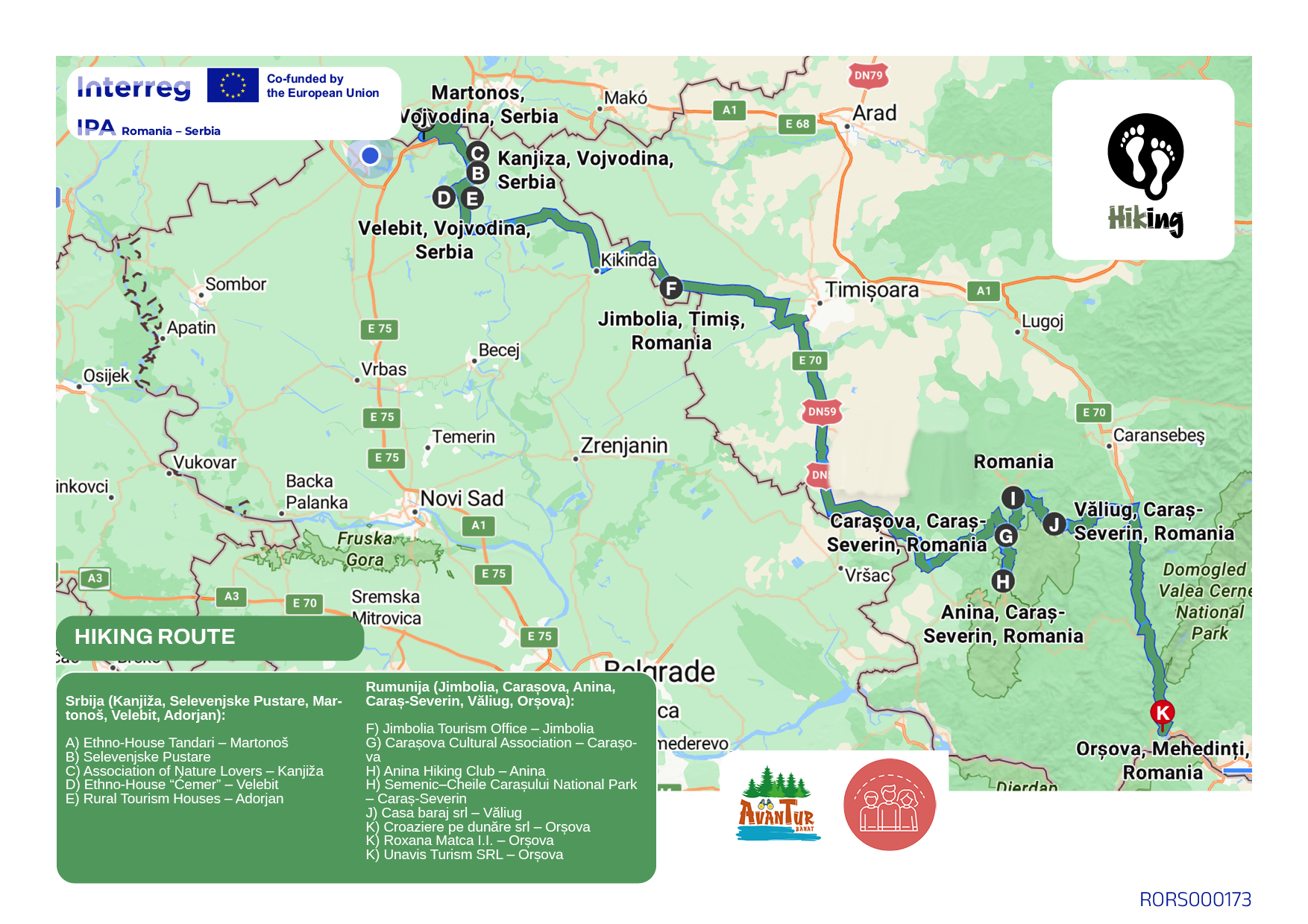
Serbian section: Kanjiža – Selevenjske Pustare – Martonoš – Velebit – Adorjan
Romanian section: Jimbolia – Carașova – Anina – Caraș-Severin – Văliug – Orșova
The route extends over approximately 180 kilometers, forming a transboundary ecological and cultural corridor that links lowland nature reserves with mountainous national parks. In Serbia, the route follows the saline pastures and riparian meadows along the Tisa, connecting natural reserves and ethno-villages. In Romania, it transitions into forest trails and limestone gorges within the Semenic–Cheile Carașului National Park, continuing to the Danube viewpoint at Orșova. This spatial design allows for multi-day hiking programs that combine eco-tourism, cultural interpretation, and community engagement — from short local circuits to cross-border expeditions.
OPERATORS AND SERVICE INTEGRATION
Serbian operators:
Association of Nature Lovers – Kanjiža: coordination of hiking trails and environmental education.
Selevenjske Pustare Nature Reserve – Kanjiža: habitat interpretation and guided tours.
Ethno-House Tandari – Martonoš: cultural presentation and traditional accommodation.
Ethno-House “Ćemer” – Velebit: craft workshops and local heritage interpretation.
Rural Tourism Houses – Adorjan: community-based lodging and gastronomy services.
Romanian operators:
Jimbolia Tourism Office – Jimbolia: cross-border visitor coordination and route promotion.
Carașova Cultural Association – Carașova: community-based cultural tourism and events.
Anina Hiking Club – Anina: management of hiking trails and mountaineering activities.
Semenic–Cheile Carașului National Park Administration – Caraș-Severin: conservation, signage, and safety coordination.
Casa Baraj SRL – Văliug: accommodation and lake-based eco-recreation.
Croaziere pe Dunăre SRL – Orșova: logistical and interpretive support for Danube viewpoints.
Roxana Matca I.I. – Orșova: small-scale eco-hospitality services.
Unavis Turism SRL – Orșova: guides and outdoor adventure logistics.
Together, these organizations form the Banat Hiking Partnership, ensuring route management, community participation, and compliance with environmental standards.
PRACTICAL TRAVEL INFORMATION
Total length: approx. 180 km
Difficulty: moderate (flat terrain in Serbia, hilly in Romania)
Recommended duration: 5–6 days (modular stages available)
Main border crossing: Srpska Crnja - Jimbolia (opened 24/7)
Best season: April–October
Facilities: marked trails, info boards, rural guesthouses, campsites, local guides
Suggested itineraries include:
“Tisa–Semenic Transition Trail” (Kanjiža–Anina, 3 days)
“Culture and Nature Circuit” (Velebit–Carașova–Orșova, 4 days)
ATTRACTIVENESS, ACCESSIBILITY, AND SERVICE ASSESSMENT
| Criterion | Evaluation Summary |
| Tourism attractiveness | Very high — exceptional combination of ecosystems, culture, and community life; high landscape diversity. |
| Regional accessibility | Good — well-connected by regional roads and rail; signage improving through joint Interreg projects. |
| Service availability | High — reliable network of guesthouses, guides, and eco-centers; minor gaps in digital navigation coverage. |
| Cross-border coherence | Excellent — unified theme, shared management structure, strong complementarity of landscapes. |
Photo Gallery
Route Map