
The Birdwatching Route – Eco Corridors of Banat
Description
The Birdwatching Route – Eco Corridors of Banat highlights one of the region’s most unique and underutilized tourism assets: its vast wetlands, saline meadows, and transboundary ecosystems that host rich avifauna and biodiversity. This route is designed to integrate the ornithological, ecological, and educational dimensions of tourism, positioning Banat as a cross-border birdwatching and conservation destination. By connecting Serbia’s Tisa wetlands and saline grasslands with Romania’s Lunca Mureșului and Satchinez marshes, the route emphasizes shared environmental responsibility and the role of tourism in supporting ecosystem preservation.
GEOGRAPHICAL AND STRUCTURAL OVERVIEW
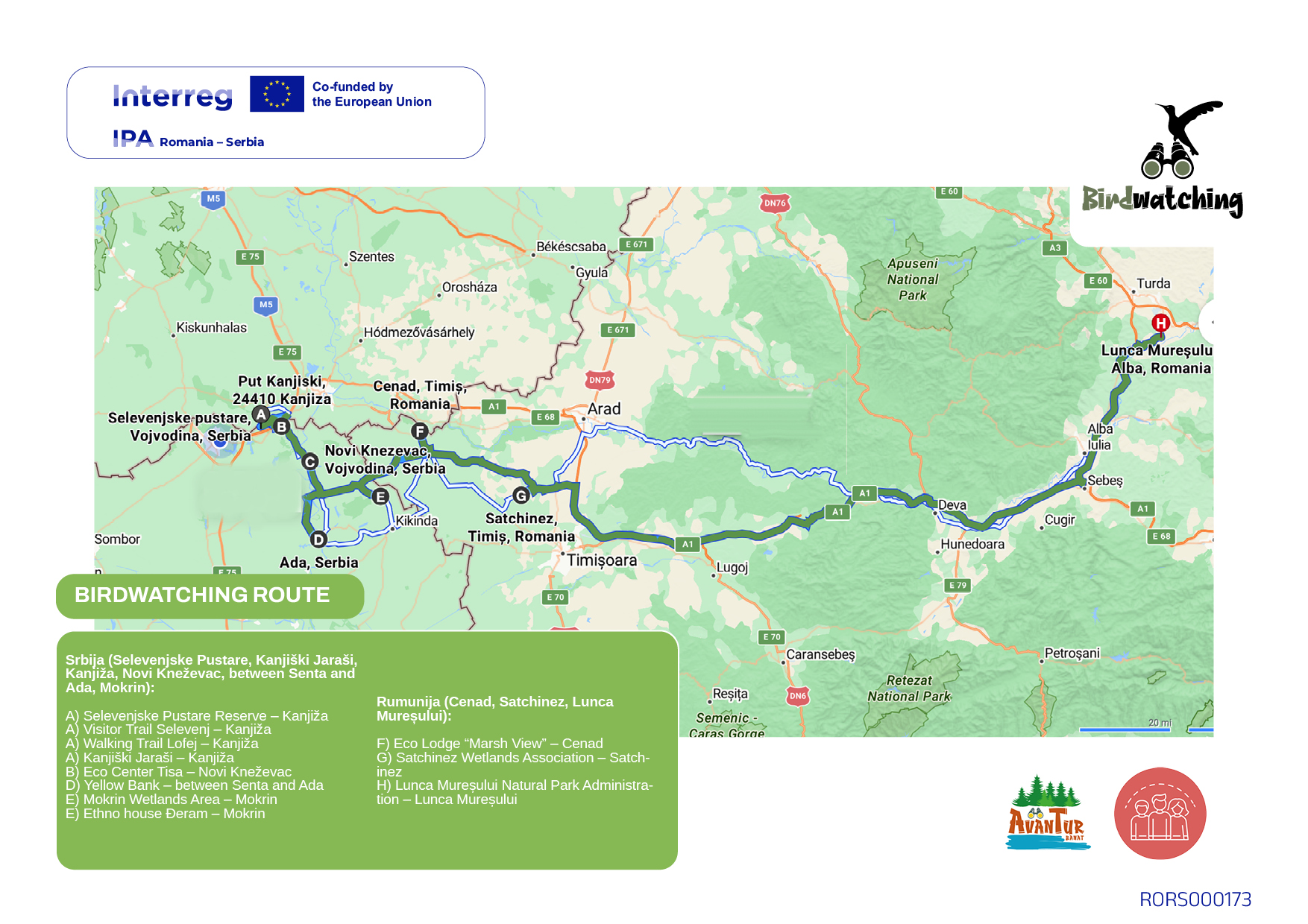
Serbian section: Selevenjske Pustare – Kanjiški Jaraši – Kanjiža – Novi Kneževac – Between Senta and Ada – Mokrin
Romanian section: Cenad – Satchinez – Lunca Mureșului
This route forms a continuous ecological axis following the migration corridors of the Tisa and Mureș rivers.
It connects key protected areas such as Selevenjske Pustare Special Nature Reserve in Serbia and Lunca Mureșului Natural Park in Romania, both recognized under international conventions (Ramsar and Natura 2000).
The linear but modular structure allows for short visits (one-day tours) and longer birdwatching circuits (2–4 days), covering a diversity of habitats: saline meadows, riparian forests, wetlands, and agricultural mosaics.
OPERATORS AND SERVICE INTEGRATION
Serbian operators:
Selevenjske Pustare Reserve – Kanjiža: management and conservation of saline steppe ecosystems.
Visitor Trail Selevenj – Kanjiža: interpretive infrastructure for birdwatching and eco-education.
Walking Trail Lofej – Kanjiža: eco-hiking and nature observation route.
Kanjiški Jaraši – Kanjiža: protected wetland area with guided tours.
Eco Center Tisa – Novi Kneževac: leading NGO in environmental education and eco-tourism.
Yellow Bank – between Senta and Ada: riverside observation point and bird photography site.
Mokrin Wetlands Area – Mokrin: managed habitats for migratory and nesting species.
Ethno House Đeram – Mokrin: cultural interpretation and hospitality for nature tourists.
Romanian operators:
Eco Lodge “Marsh View” – Cenad: eco-accommodation integrated with local observation platforms.
Satchinez Wetlands Association – Satchinez: coordinates wetland restoration and birdwatching events.
Lunca Mureșului Natural Park Administration – Lunca Mureșului: oversees conservation, guides, and visitor centers.
Collectively, these operators form an eco-tourism cluster that bridges scientific conservation with educational and recreational tourism. The cooperation between reserve administrations, NGOs, and private eco-lodges ensures environmental sustainability, monitoring, and interpretation across the entire route.
PRACTICAL TRAVEL INFORMATION
Total length: approx. 140 km
Best season: March–May and September–October (migration periods)
Difficulty: easy; suitable for families, schools, and photography groups
Main border crossing: Nakovo – Lunga (opened 8-20h)
Facilities: observation towers, rest shelters, field stations, local eco-lodges, and guided tours
Suggested itineraries include:
Wetlands and Meadows Trail (Selevenjske Pustare – Kanjiža – Cenad)
Marshes and Rivers Trail (Satchinez – Lunca Mureșului)
ATTRACTIVENESS, ACCESSIBILITY, AND SERVICE ASSESSMENT
| Criterion | Evaluation Summary |
| Tourism attractiveness | Very high — exceptional biodiversity, educational value, and photography potential. |
| Regional accessibility | Good — paved and rural access roads; minor improvements needed in signage near protected areas. |
| Service availability | High — strong network of guides, eco-lodges, and interpretation centers; digital support tools expanding. |
| Cross-border coherence | Excellent — continuous ecological landscape and joint conservation projects under Interreg CBC initiatives. |
Photo Gallery
Route Map